
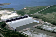
Glen Elder Dam-Bureau of Reclamation
Overview
The Solomon River has carved a broad U-shaped valley into flat-lying Cretaceous-aged sedimentary rocks at the site of Glen Elder Dam. The valley walls which serve as abutments for the dam are composed of limestone and shales primarily of Greenhorn Limestone; the upper portion of abutments are chalky shale and limestones of the Carlile Shale. The upper surface of these rocks are weathered to depths of 20 to 30 feet; near vertical joints are common. A thin 10 to 20-foot mantle of loessal silts and clays with some sand forms the upper surface of the left abutment. A near vertical bluff of limestone and shale, which was formed by downcutting of the river and excavation for the railroad line, is the inner edge of the left abutment. Ten to 20 feet of eolian silt and clay also cap the Carlile Shale and Greenhorn Limestone of the right abutment. The inner portion of the right abutment is a 40 to 60 foot thick terrace deposit primarily of silt and clay with 10+ feet of sand at its base and lying on Greenhorn Limestone. The center section of the valley floor has a width of 7,000 feet and is underlain by 30 to 60 feet of unconsolidated alluvium on silts, clays and sand. Silts and clays comprise the upper two thirds to three fourths of the alluvium with the lower one fourth to one third consisting of silty and poorly graded sands. Prior to deposition of these sediments, the downcutting and scouring action had removed weathered bedrock and as a result, these sediments rest on unweathered Graneros Shale.

Learn more about Beloit, Cawker City, Glen Elder, Hunter, Scottsville, Simpson, Tipton and our other communities.
SEE FULL LIST